
By Ben Schechter
Here is a map of our road trip ! I also included a little info on where we stopped.
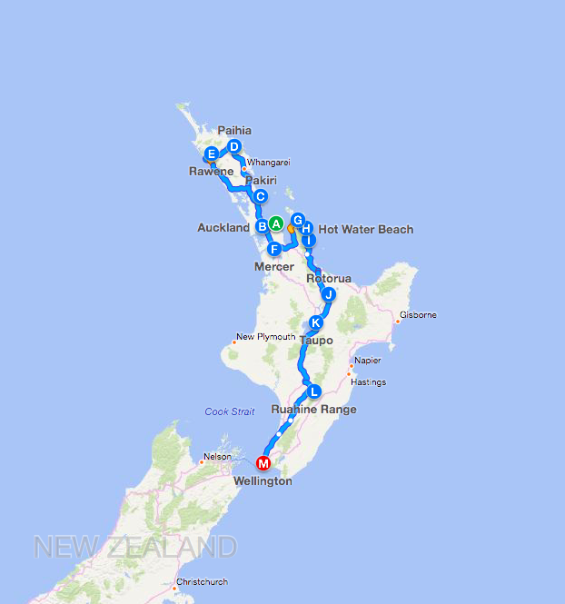
North Island
- Waiheke Island- where we first stayed, many beaches
- Auckland- Sky tower and Auckland Aquarium are both here
- Pakiri Beach- the first campsite we went to
- Bay Of Islands/Paihia – Hole in the Rock and Russell
- Rawene- Sand Dune Sledding
- Waipoua Forest- home to the huge 2,000 year old kauri tree, Tane Mahuta
- Wellsford- a farmhouse we stayed for one night
- Mercer- farm where we camped for the night
- Coromandel peninsula
- Whangapoua- New Chums Beach is one of the top 10 beaches in the world!
- Hot Water Beach- at low tide if you dig in the right spot you will hit hot water!
- Whangamata- a surfing town where Paula took a surfing lesson
- Cook’s Cove- A bay with many caves we took a boat tour
- Rotorua- a geothermal town that stinks because of sulfur
- Lake Taupo- the largest lake in New Zealand
- Ruahine Mtns – a sheep and horse farm where we stayed
- Wellington – the capital of NZ
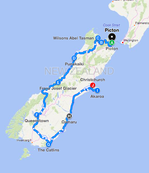
South Island
- Picton/Marlborough – where the ferry arrived and location of Smith’s Farm
- Nelson – the town where we got haircuts
- Abel Tasman – national park
- Punakaiki – pancake rocks
- Franz Josef – glacier
- Queenstown/Wanaka – Helicopter to Milford Sound, jet boating, and luging
- Catlins – sea lions
- Oamaru – penguins
- Akaroa – dolphins
- Christchurch – where we flew to Australia
Cool post Ben. I liked how you put a little info of each place you stopped.?
Wow, Ben! You really went to a lot of places. I think you covered both islands.
Wow, Ben, you guys stopped at a lot of places. I think you definitely covered both islands!